
 Locate where any photo was taken no metadata required
Overview
GeoInfer is an AI-powered image geolocation platform developed specifically for investigators, researchers, law enforcement, journalists, and security professionals.
It processes and analyzes visual cues such as architecture, terrain, vegetation, and environmental markers within photos to identify the geographical location where the photo was taken.
This AI system works even in the absence of EXIF or GPS data from metadata, making it highly reliable for images that come from sources like social media or messaging apps where metadata may be stripped.The platform relies on deep learning models that are trained on millions of geotagged images to enable precise location detection from any photo worldwide.
Its comprehensive database covers urban centers, natural landscapes, and remote locations, leading to accurate photo location detection.GeoInfer's real-time processing capabilities enable seamless integration into professional workflows and provide subsecond AI image search processing.
The platform can find location from image files even when GPS data has been removed or was never present, analysing visual content rather than embedded location data.GeoInfer offers wide coverage as it is trained on data from every continent, giving it the ability to accurately analyze photos taken anywhere in the world.
However, accuracy may vary depending on the density of reference imagery in the platforms training data. Urban areas and popular locations generally yield higher precision results.GeoInfer serves several professional use cases like verifying locations in open-source intelligence gathering and threat assessment, authenticating and geolocating evidence in legal and investigative contexts, and analyzing and verifying visual content for security and compliance purposes.
Releases

Pricing
Top alternatives
-
James Mcgill🙏 106 karmaJun 18, 2025@GeoFinderAIThis thing is actually insane. I uploaded a picture from a random hike I did years ago, and it guessed the location exactly. Not just the country but the exact trail. I have no idea how it works, but its pretty impressive.
-
I tried other tools aswell, this was the only accurate. Other ais didn't even get the country right. Compared to the others it had the advantage that I could specify the area in which the location was. I only tried it once so far but I am satisfied.
-
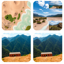 Turn geographical clues into ultra-realistic location images.Open


